This article was first published on iklimriskleri.com and migrated with a July 2026 update.
Wildfires rank among the most destructive acute physical risks of climate change. Türkiye’s 2025 fire season, which affected 53 provinces, and the July 2026 events in Torbalı, İzmir — where flames forced the evacuation of industrial facilities — showed that the risk now concerns not only forests but the entire economy, from tourism to manufacturing, from energy infrastructure to supply chains. In this guide, we summarize the fire-climate relationship, Türkiye’s 2025-2026 picture, the risks to industry and energy, and the link to climate-disclosure reporting under IFRS S2 / ISSB.
How Does Climate Change Fuel Wildfires?
Rising temperatures, falling humidity and longer dry spells are making forests more flammable; in many regions the fire season has lengthened by roughly a month over the past 35 years. A warming atmosphere dries out vegetation and increases the amount of combustible material, while shifts in snowmelt and precipitation patterns leave forests dry for longer.
The result is measurable: human-driven climate change has increased “fuel aridity,” and the cumulative burned forest area has nearly doubled since 1984. The extent of flammable land exposed to long fire seasons worldwide has likewise doubled in recent years. Insurance industry figures confirm that the frequency and intensity of “extreme” wildfires have more than doubled over the past two decades.
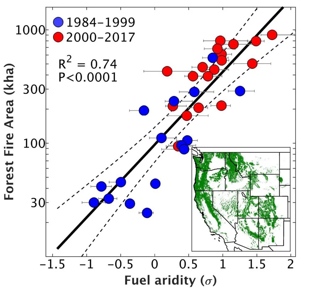
The scale is global: Canada lost about 15 million hectares in 2023, a season with temperatures running 2.2°C above normal — more than twice its worst season on record, 1989. Australia’s 2019-2020 “Black Summer” burned more than 24 million hectares. From Siberia to California, from the Amazon to the Mediterranean basin, fire seasons are reported to be both lengthening and intensifying.
Türkiye’s 2025-2026 Wildfire Picture
Long-term statistics show the risk growing structurally: while the 1988-2000 period averaged ~1,900 fires per year, the average has risen to ~2,700 since 2011 (figures from İstanbul University-Cerrahpaşa, Department of Forest Engineering). Burned area, meanwhile, swings widely from year to year: roughly 140,000 hectares in 2021, around 15,000 hectares in 2023. How a single dry, windy season can multiply the toll was painfully confirmed in 2025.
The 2025 season wrote one of the heaviest tolls in Türkiye’s fire history: fires struck 53 provinces; 17 people lost their lives, 96 were injured and more than 50,000 were evacuated. The gravest event came on July 23, 2025 in Seyitgazi, Eskişehir: a 10-person crew of 5 forestry workers and 5 AKUT volunteers was trapped by flames that suddenly changed direction and lost their lives.
On total burned area, it pays to watch what each source actually measures:
| Source | Coverage | 2025 figure |
|---|---|---|
| OGM (Turkish General Directorate of Forestry) | Forest land in official records | ~49,769 hectares across 4,426 fires |
| Media compilations | Forest plus rural land combined | More than 80,000 hectares |
| EFFIS (EU satellite monitoring system) | All burn scars detected by satellite | 162,188 hectares |
The gap is not a contradiction but a difference of definition: OGM counts only land under the forest regime, media compilations add rural and agricultural fires, and EFFIS measures every burn scar visible in satellite imagery. That is why any figure used in reporting must state its source and scope. According to EFFIS, 2025 was also a record year across the European Union, with more than 1 million hectares burned.
The 2026 season also started early and active: on June 26, fires broke out in Balıkesir, Antalya and Çanakkale on the same day. On July 14-15, 2026, a fire affecting roughly 850 hectares in Milas, Muğla forced the evacuation of 1,120 people, including hotels and holiday resorts. The very next day, July 16, flames reached the industrial zone in Torbalı, İzmir, and factories were evacuated.
Concrete Risks for Industrial and Energy Facilities
Severe fires can directly damage factories, refineries and power plants. Energy and renewables investments are not outside the risk either: smoke and heat cut solar panel output and cause failures on transmission lines. On top of physical damage come production interruptions, lost revenue, rising insurance premiums and maintenance costs. The evacuation of factories in Torbalı entered the record as this chain’s real-world example in Türkiye.
Wind and solar plants demand special precautions: in 2023, major fires around the world temporarily halted or degraded many solar and wind projects. Analyzing fire risk in advance for sites and transmission lines makes it possible to plan proactive steps such as clearing dry vegetation and keeping firefighting equipment at the ready. The financial dimension keeps growing too: wildfire losses in 2017-2021 are estimated to have reached USD 81.6 billion — a ninefold increase over the previous five years.
From industrial and manufacturing facilities to energy infrastructure, organizations that want to measure this risk can turn to UrClimate Score, which rates wildfire risk in spatial and temporal terms: for any geographic point, current hazard and the risk levels expected through 2050 under different climate scenarios can be delivered year by year, at resolution reaching down to the neighborhood level.
Early Warning and Climate-Disclosure Reporting
Satellite fire detection systems, meteorological indices such as the Fire Weather Index, and NASA- and NOAA-based forecasts track temperature, humidity, wind and soil moisture in real time, flagging high-risk conditions days in advance. Machine learning is in play as well: Bentivegna’s (2024) Google Earth Engine-based model regularly refreshes fire risk maps from climate, terrain and vegetation parameters. Early warning cannot prevent fires entirely, but it can sharply reduce the scale of damage and the loss of life.
On the reporting side, the global baseline is IFRS S2 Climate-related Disclosures, issued by the ISSB in June 2023 and built on the TCFD framework (governance, strategy, risk management, metrics and targets), effective for annual periods beginning on or after 1 January 2024. IFRS S2 lists wildfires among acute physical risks and requires their impacts on assets and supply chains to be assessed over the short, medium and long term. In Türkiye, IFRS S2 is adopted nationally as TSRS 2: the first TSRS reports were published in the fall of 2025, after KGK (Türkiye’s Public Oversight Authority) extended the deadline to October 31, 2025; reports from THY (Turkish Airlines) and Arçelik to VakıfBank and Türk Telekom are publicly available on the KGK portal. CMIP6-based climate scenarios remain the accepted reference for scenario analysis.
Right at this point, UrClimate Next makes it possible to monitor hazard levels at asset locations through fire risk maps and GIS integration, and to produce IFRS S2-aligned inputs such as estimated loss amounts and operational downtime under a “worst-case scenario.” Decisions — from reinforcing suppression infrastructure to taking operational precautions in high-risk seasons — can then be planned on the strength of the numbers.
In short, the science clearly shows that fire seasons are getting longer and more intense, and Türkiye’s 2025-2026 experience showed the risk spilling over from forests into tourism and industry. Preparing for the seasons ahead begins with steps that can be taken today — from managing combustible vegetation around facilities and evacuation planning to reviewing insurance coverage and deploying early warning systems.